
Ride Profiles
The Alpine Challenge Ride consists ofa 25 mile Alpine Ride, a 50 Mile Descanso Ride, a 62 Mile Pine Valley Ride and a 100 Mile Mount Laguna Ride.
 We're returning to Summers Past
Farms in the Flinn Springs area just west
of Alpine.
There will be a large tented area in a grassy field - lots of shade for our post-ride
festivities.
Because of the road (Olde Highway 80) and businesses as you leave towards Harbison
Canyon, we have a "leave when you are ready" format. We are doing it
for your safety and enjoyment.
We're returning to Summers Past
Farms in the Flinn Springs area just west
of Alpine.
There will be a large tented area in a grassy field - lots of shade for our post-ride
festivities.
Because of the road (Olde Highway 80) and businesses as you leave towards Harbison
Canyon, we have a "leave when you are ready" format. We are doing it
for your safety and enjoyment.

General Information
Start and Finish:Summers Past Farms
15602 Olde Highway 80
El Cajon, CA 92021
(619) 390-1523


Directions
From Interstate 8, exit at the Harbison Canyon/Dunbar Lane exit (it is the exit just before the Alpine/Tavern Road exit) and turn left at the stop sign (North) to cross under the freeway.Turn left at the first road (Olde Highway 80). In one mile, Summers Past Farms is on the right at Hawley Road. Personnel and signs will lead you to the registration area.
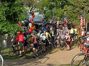
Post-Ride festivities include lunch, a massage, a drink ticket, Beer Garden, music, and more.
This is a ride not a race. Helmets are required.
Participants must obey all traffic laws. Ride as close to the right side as possible and within the bicycle lane wherever possible. Ride in single file.
| Fees | |
|---|---|
| Active.com: | $55 Pre-Registration before April 8th 2018 |
| $75 Registration from April 8th through April 18th | |
| Mail-In: | $55 Pre-Registration postmarked before April 8th |
| $75 Registration postmarked thereafter | |
| Event Day Registration is acceptable, however, the 10% discount will not apply. Tandem entries are an additional $15 for the second rider. Please provide name. Non-Rider meals are $5 for adult or child. 10% discount for Team, Student, Club and Military riders but please bring proof of status. |
|
| Schedule | |
|---|---|
| 6:00 am | Registration Opens |
| 6:00 am - 8:30 am | Ride Start Time for Mount Laguna, Pine Valley and Descanso Rides |
| 7:15 am | Registration closes for Mount Laguna Ride |
| 8:15 am | Registration closes for Pine Valley and Descanso Rides |
| 8:30 am - 9:30 am | Ride Start Time for Alpine Ride |
| 9:15 am | Registration closes for Alpine Ride |
| 11:00 am - 4:30 pm | Beer Garden and Massage available |
| 11:30 am - 4:00 pm | Post-Ride Meal |
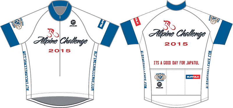
Alpine Ride
Route map (PDF) - Garmin results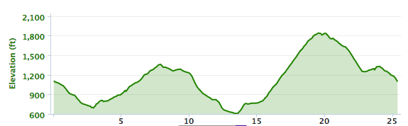 2,013 ft
The Alpine Ride route is designed for the seasoned rider and provides a
strenuous but doable ride both east and south of Alpine. If you're a
"weekend warrior" looking to go to the next level, this challenge is
also for you. You will begin by going west to Lake Jennings Road and
then travel back east on Blossom Valley Road and Flynn Spring Road.
After returning to ride past Summers Past Farms, you will head east to
Harbison Canyon, then up to Alpine and back to Summers Past Farms.
During the course of this ride you will enjoy some of the area's most
beautiful rural roads. The Dehesa Grade climb, with 1,000 feet of
elevation gain, will challenge you - but your efforts will be rewarded
with refreshments and water at the top of the climb. Stick around to
enjoy the festivities in the park.
Sign up now and bring a friend!
| Miles | CumMiles | Directions |
|---|---|---|
| Start at the Summers Past Farms –Right onto Old Hwy 80 (West) | ||
| 2.9 | 2.9 | Turn Right (North) onto Lake Jennings Rd. |
| 0.2 | 3.1 | Turn Right (East) onto Blossum Valley Rd. |
| 1.6 | 4.7 | Turn Right (South) onto Flinn Spring Rd. |
| 0.6 | 5.3 | Turn Left (East) onto Old Hwy 80 |
| 1.9 | 7.2 | Turn Right (South) onto Dunbar Ln. - go under freeway |
| 0.1 | 7.3 | Turn Left (East) onto Alpine Blvd. |
| 0.6 | 7.9 | Turn Right (South) at stop sign onto Arnold Way |
| 0.8 | 8.7 | Turn Right (South) onto Harbison Canyon Rd. |
| 4.6 | 13.3 | Turn Left (East) onto Dehesa Rd. |
| 4.6 | 17.9 | SAG Stop - Top of Dehesa Rd. |
| 0.2 | 18.1 | Turn Left (West/then North) onto Tavern Rd. |
| 1.0 | 19.1 | SAG Stop - Right Side; Just Before So Grade Rd. intersection |
| 1.5 | 20.6 | Turn Left (West) onto Arnold Way |
| 3.0 | 23.6 | Turn Left (West) at Stop Sign onto Alpine Blvd. |
| 0.6 | 24.2 | Turn Right (North) onto Dunbar Ln. |
| 0.1 | 24.3 | Turn Left (West) onto Old Hwy 80 |
| 0.9 | 25.2 | Finish at Summers Past Farms |
Descanso Ride
Route map (PDF) - Garmin results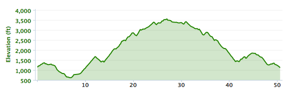 5,318 ft
The Descanso Ride measures 51 miles . It remains one of the toughest rides in California.
Riders will be amply rewarded through not only completing the challenge but also
in the sheer enjoyment of the long, long, downhills, quiet country roads and
spectacular mountain scenery. This is not for the casual rider and the experienced
riders are encouraged to start training early. Don't miss this awesome ride.
Sign up now and bring a friend!
| Miles | CumMiles | Directions |
|---|---|---|
| Start at the Summers Past Farms -Left onto Old Hwy 80 (East) | ||
| 0.9 | 0.9 | Turn Right (South) onto Dunbar Ln - go under freeway |
| 0.1 | 1.0 | Turn Left (East) onto Alpine Blvd. |
| 0.6 | 1.6 | Turn Right (South) at stop sign onto Arnold Way |
| 0.8 | 2.4 | Turn Right (South) onto Harbison Canyon Rd. |
| 4.6 | 7.0 | Turn Left (East) onto Dehesa Rd. |
| 4.6 | 11.6 | SAG Stop - Top of Dehesa Rd. |
| 0.2 | 11.8 | Turn Right (East) onto Japatul Rd. |
| 7.1 | 18.9 | Japatul Rd. becomes Japatul Valley Rd. at Lyons Valley Rd. |
| 0.9 | 19.8 | SAG Stop - Right Side; just past Lyons Valley Rd. junction |
| Japatul Valley Rd. becomes Old Hwy 80 at I-8 | ||
| 7.5 | 27.3 | Turn Left (North) onto Hwy 79 |
| SAG Stop - Right Side; just past Hwy 79 Turn-off | ||
| 0.2 | 27.5 | Turn Left (West) onto Viejas Blvd. (becomes Riverside Dr. going South) |
| 2.6 | 30.1 | Turn Right (South/West) onto Old Hwy 80 |
| Old Hwy 80 becomes Japatul Valley Rd. at I-8 | ||
| 6.0 | 36.1 | SAG Stop - Left Side; just before Lyons Valley Rd. junction |
| 0.9 | 37.0 | Japatul Valley Rd. becomes Japatul Rd. at Lyons Valley Rd. |
| 7.1 | 44.1 | Japatul Rd. becomes Tavern Rd. at Dehesa Rd. junction |
| Continue on Tavern Rd. (West, then North) | ||
| 1.0 | 45.1 | SAG Stop - Right Side; just before So. Grade Rd. intersection |
| 1.5 | 46.6 | Turn Left (West) onto Arnold Way |
| 3.0 | 49.6 | Turn Left (West) at stop sign onto Alpine Blvd |
| 0.6 | 50.2 | Turn Right (North) onto Dunbar Ln. |
| 0.1 | 50.3 | Turn Left (West) onto Old Hwy 80 |
| 0.9 | 51.2 | Finish at Summers Past Farms |
Pine Valley Ride
Route map (PDF) - Garmin results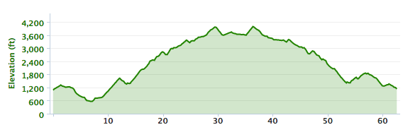 6,398 ft
When the Descanso riders turn towards Julian on Hwy
79, this ride continues east and rides through Guatay and Pine Valley. In Pine
Valley, we tour an area on the Pine Valley Creek and then return to Hwy 79. There
is a SAG stop on Valley View Trail. This colorful extension adds 12 miles to the Descanso Ride - a total
of 63 miles - this will be the
ultimate challenge!
Sign up now and bring a friend!
| Miles | CumMiles | Directions |
|---|---|---|
| Start at the Summers Past Farms - Left onto Old Hwy 80 (East) | ||
| 0.9 | 0.9 | Turn Right (South) onto Dunbar Ln - go under freeway |
| 1.0 | 1.0 | Turn Left (East) onto Alpine Blvd. |
| 0.6 | 1.6 | Turn Right (South) at Stop Sign onto Arnold Way |
| 0.8 | 2.4 | Turn Right (South) onto Harbison Canyon Rd. |
| 4.6 | 7.0 | Turn Left (East) onto Dehesa Rd. |
| 4.6 | 11.6 | SAG Stop - Top of Dehesa Rd. |
| 0.2 | 11.8 | Turn Right (East) onto Japatul Rd. |
| 7.1 | 18.9 | Japatul Rd. becomes Japatul Valley Rd. at Lyons Valley Rd. |
| 0.9 | 19.8 | SAG Stop - Right Side; just past Lyons Valley Rd. junction |
| Japatul Valley Rd. becomes Old Hwy 80 at I-8 | ||
| 7.6 | 27.4 | SAG Stop - Right Side; just past Hwy 79 Turn-off |
| 5.3 | 32.7 | Turn Left (North) onto Laguna Trail |
| 0.1 | 32.8 | Turn Left (West/then North) onto Pine Blvd. |
| Slight Left as Pine Blvd. becomes Spruce Rd. | ||
| Slight Right as Spruce Rd. becomes Valley View Tr. | ||
| 1.1 | 33.9 | SAG Stop - Right Side |
| 0.6 | 34.5 | Turn Left (West) onto Pine Creek Crossing |
| 0.1 | 34.6 | Turn Left (South) onto Pine Creek Rd. |
| 0.9 | 35.5 | Turn Right (West) onto Old Hwy 80 |
| 3.8 | 39.3 | SAG Stop - Left Side; just before Hwy 79 Turn-off |
| 0.1 | 39.4 | Turn Right (North) onto Hwy 79 |
| 0.2 | 39.6 | Turn Left (West) onto Viejas Blvd. (becomes Riverside Dr. going South) |
| 2.6 | 42.2 | Turn Right (South/West) onto Old Hwy 80 |
| Old Hwy 80 becomes Japatul Valley Rd. at I-8 | ||
| 6.0 | 48.2 | SAG Stop - Left Side; just before Lyons Valley Rd. junction |
| 0.9 | 49.1 | Japatul Valley Rd becomes Japatul Rd. at Lyons Valley Rd. |
| 7.1 | 56.2 | Japatul Rd. becomes Tavern Rd. at Dehesa Rd. junction |
| Continue on Tavern Rd. (West/then North) | ||
| 1.0 | 57.2 | SAG Stop - Right Side; just before So. Grade Rd. intersection |
| 1.5 | 58.7 | Turn Left (West) onto Arnold Way |
| 3.0 | 61.7 | Turn Left (West) at Stop Sign onto Alpine Blvd |
| 0.6 | 62.3 | Turn Right (North) onto Dunbar Ln. |
| 0.1 | 62.4 | Turn Left (West) onto Old Hwy 80 |
| 0.9 | 63.3 | Finish at Summers Past Farms |
Mount Laguna Ride
Route map (PDF) - Garmin results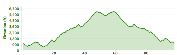 10,148 ft
When you enter the town of Pine Valley on Old Hwy 80 and the Pine Valley
riders turn into town, you continue on Old Hwy 80 to the "T"
intersection with Sunrise Highway. You will turn north onto Sunrise
highway and continue up into the Cleveland National Forest. You will
ride for 13 miles until you reach the Penny Pines Turnout. At that
point you turn around and retrace your route down to Old Hwy 80 and into
Pine Valley. This extension adds 35 miles to the ride with a total
elevation gain of 10,150 feet. As you ride into Pine Valley you will
turn north onto the Pine Valley Ride route and continue back to Alpine
and Summers Past Farms.
Sign up now and bring a friend!
| Miles | CumMiles | Directions |
|---|---|---|
| Start at the Summers Past Farms and turn right onto Old Hwy 80 (West) | ||
| 2.9 | 2.9 | Turn right (North) onto Lake Jennings Road |
| 0.2 | 3.1 | Turn right (east) onto Blossum Valley Road |
| 1.6 | 4.7 | Turn Right (South) onto Flinn Spring Rd. |
| 0.6 | 5.3 | Turn Left (East) onto Old Hwy 80 |
| 1.9 | 7.2 | Turn Right (South) onto Dunbar Lane - go under freeway |
| 0.1 | 7.3 | Turn Left (East) onto Alpine Blvd. |
| 0.6 | 7.9 | Turn Right (South) at stop sign onto Arnold Way |
| 0.8 | 8.7 | Turn Right (South) onto Harbison Canyon Rd |
| 4.6 | 13.3 | Turn Left (East) onto Dehesa Rd. |
| 4.6 | 17.9 | SAG Stop - Top of Dehesa Rd. |
| 0.2 | 18.1 | Turn Right (East) onto Japatul Rd. |
| 7.1 | 25.2 | Japatul Rd. becomes Japatul Valley Rd. at Lyons Valley Rd. |
| 0.9 | 26.1 | SAG Stop - Right Side; just past Lyons Valley Rd. junction |
| Japatul Valley Rd. becomes Old Hwy 80 at I-8 | ||
| 7.6 | 33.7 | SAG Stop - Right Side; just past Hwy 79 Turn-off |
| 6.4 | 40.1 | Turn left (North) at Sunrise Hwy |
| 0.8 | 40.9 | SAG Stop - Right Side; Turnout |
| 4.5 | 45.4 | On Right - 2 PortaPotties and a Call Box |
| 3.5 | 48.9 | On Left-Volunteer Activities Center (PortaPottie) On Right - Mt. Laguna Fire Station |
| 0.8 | 49.7 | Laguna Mountain Visitors Center (PortaPottie) Mt Laguna Store (food/beverages for purchase) |
| 3.9 | 53.6 | TURN AROUND AREA - Penny Pines Turnout & Sunrise Winter Gate |
| 3.9 | 57.5 | Laguna Mountain Visitors Center |
| 0.8 | 58.3 | On Left-Volunteer Activities Center (PortaPottie) On Right - Mt. Laguna Fire Station |
| 3.5 | 61.8 | On Right - 2 PortaPotties and a Call Box |
| 0.8 | 62.6 | SAG Stop - Left Side; Turnout |
| 4.5 | 67.1 | Turn right (West) at Old Hwy 80 |
| 1.1 | 68.2 | Turn right (North) onto Pine Blvd. |
| 0.1 | 68.3 | Slight Left (West/then North) to continue on Pine Blvd. |
| Slight Left as Pine Blvd. becomes Spruce Rd. | ||
| Slight Right as Spruce Rd. becomes Valley View Tr. | ||
| 1.1 | 69.4 | SAG Stop - Right Side |
| 0.6 | 70.0 | Turn Left (West) onto Pine Creek Crossing |
| 0.1 | 70.1 | Turn Left (South) onto Pine Creek Rd. |
| 0.9 | 71.0 | Turn Right (West) onto Old Hwy 80 |
| 3.8 | 74.8 | SAG Stop - Left Side; just before Hwy 79 Turn-off |
| 0.1 | 74.9 | Turn Right (North) onto Hwy 79 |
| 0.2 | 75.1 | Turn Left (West) onto Viejas Blvd. (becomes Riverside Dr. going South) |
| 2.6 | 77.7 | Turn Right (South/West) onto Old Hwy 80 |
| Old Hwy 80 becomes Japatul Valley Rd. at I-8 | ||
| 6.0 | 83.7 | SAG Stop - Left Side; just before Lyons Valley Rd. junction |
| 0.9 | 84.6 | Japatul Valley Rd becomes Japatul Rd. at Lyons Valley Rd. |
| 7.1 | 91.7 | Japatul Rd. becomes Tavern Rd. at Dehesa Rd. junction |
| Continue on Tavern Rd. (West/then North) | ||
| 1.0 | 92.7 | SAG Stop - Right Side; just before So. Grade Rd. intersection |
| 1.5 | 94.2 | Turn Left (West) onto Arnold Way |
| 3.0 | 97.2 | Turn Left (West) at Stop Sign onto Alpine Blvd |
| 0.6 | 97.8 | Turn Right (North) onto Dunbar Ln. |
| 0.1 | 97.9 | Turn Left (West) onto Old Hwy 80 |
| 0.9 | 98.8 | Finish at Summers Past Farms |